Arctic Front Brings Friday Snow Squalls, Dangerous Cold Through Sunday
A blast of Arctic air is set to sweep across the Northeast this weekend, beginning with widespread snow squalls on Friday and giving way to life-threatening wind chills through Sunday morning. The National Weather Service is warning residents to prepare for hazardous travel, rapidly falling temperatures, and prolonged exposure to extreme cold.
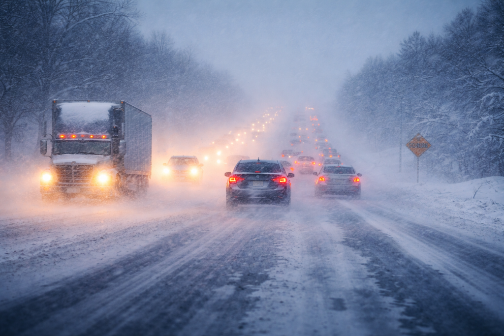
The Arctic cold front will move through the Great Lakes and Ohio Valley before reaching the Northeast on Friday, February 6. As it advances eastward, weather conditions are expected to change quickly, particularly during the evening commute. Snow showers and more intense snow squalls will develop along the front, reducing visibility and coating roads with ice and snow in a matter of minutes.
Snow squalls behave differently from steady snow, often creating abrupt whiteout conditions that catch drivers off guard. A roadway that seems safe can quickly become icy and treacherous without notice.
AccuWeather Meteorologist Peyton Simmers explained what travelers should expect:
“Snow showers and snow squalls are going to accompany the Arctic cold front as it traverses the Northeast on Friday. These snow showers and squalls can limit visibility and lead to roads becoming snow-covered and icy quickly.”
Because the front arrives during late afternoon and evening hours, thousands of commuters are likely to encounter rapidly deteriorating conditions on their way home from work.
Once the snow moves through, the focus turns to the bitter Arctic air mass settling over the region. Strong northwest winds behind the front will push temperatures far below normal and drive wind chills into dangerous territory.
From Saturday night, February 7, into Sunday morning, February 8, wind chills are forecast to range from 15 to 20 degrees below zero. The National Weather Service warns that these conditions could be life-threatening for anyone exposed to the cold for extended periods.
Actual air temperatures are expected to fall 15 to 25 degrees below historical averages for early February. The combination of frigid air and gusty winds will make even brief outdoor exposure hazardous, with frostbite possible on exposed skin within minutes.
As the cold deepens, energy demand will rise sharply across Cumberland County and surrounding areas. Homes and businesses will increase heating use, placing additional pressure on power systems and fuel supplies. Prolonged low temperatures may also threaten water pipes, particularly in unheated spaces or older infrastructure.
AccuWeather reports that this stretch of extreme cold will set the stage for additional snow and ice events through February as moisture systems interact with the Arctic air. Some parts of the Northeast could finish the month with average temperatures more than 10 degrees below normal.
This Arctic blast is the latest phase of a cold pattern that started in mid-January and has continued across much of the region. The ongoing stretch of frigid weather has already disrupted daily routines, driven higher energy use, and complicated agricultural operations, with additional effects likely as the cold lingers.
Gusty winds accompanying the Arctic air will intensify the chill and raise the risk of frostbite and hypothermia. Wind-driven cold will make it unsafe to remain outdoors without proper protection.
Officials are urging residents to take preventive steps before the worst of the cold arrives. People are advised to limit outdoor exposure, dress in layers, and cover all exposed skin.
Pet owners should bring animals indoors whenever possible or provide adequate shelter with wind protection and bedding. Livestock operations need to monitor water sources closely so they do not freeze, and animals must have sufficient shelter from the wind.
Homeowners are being advised to protect plumbing by allowing faucets to drip, keeping garage doors closed if water lines run through those spaces, and opening cabinet doors under sinks so warm air can circulate around pipes.
Forecasters expect the most extreme conditions to last through the weekend before temperatures begin to moderate early next week. Even so, below-normal temperatures are likely to persist for the remainder of February, keeping the risk of additional winter weather in place.
Residents are encouraged to monitor forecasts closely as conditions can change rapidly during periods of extreme cold.