The Untold Story of New Jersey History: When the State Was Split in Two for 28 Years
It’s hard to imagine New Jersey as anything but one unified state today.
However, for nearly three decades, from 1674 to 1702, it was actually split into two separate regions: East Jersey and West Jersey.
They had different governments, ways of life, and even approaches to land ownership.
The divide happened because of disputes, changing leadership, and the complicated politics of early colonial times.
And even though New Jersey eventually reunited, the cultural split that began during those early years still lingers in ways you might not even realize.
To understand how this happened, we need to go back to the late 1600s, when the English took control of the area from the Dutch after the Anglo-Dutch War.
In 1674, the English crown granted the land to two men: Sir George Carteret and Lord John Berkeley.
Carteret took charge of the eastern portion, and Berkeley controlled the west.
At first, it seemed like a logical way to divide the territory, but things became complicated in practice.
For one, there was no clear boundary line at the start, and as settlers arrived, land disputes became common.
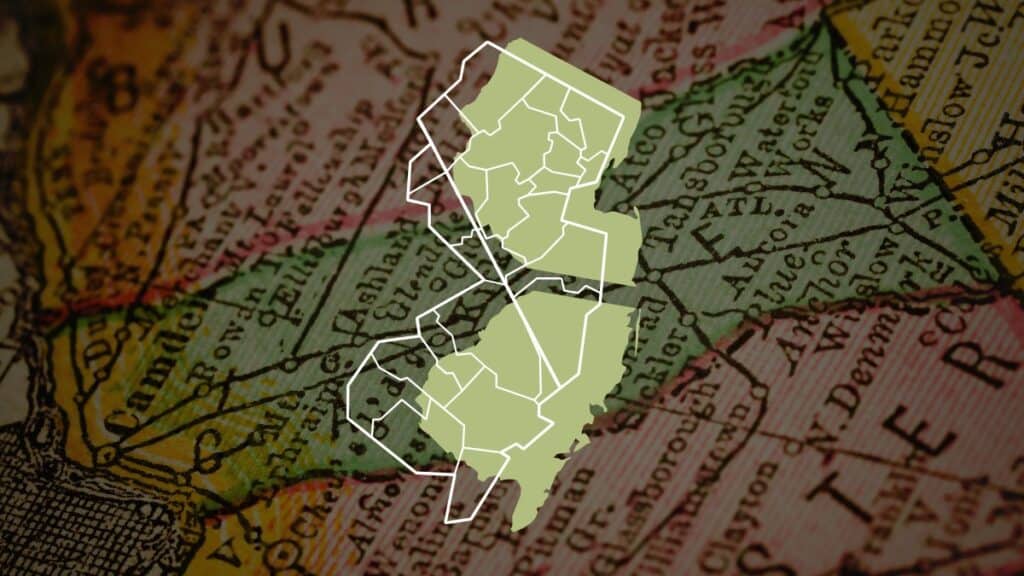
Eventually, after much debate, several borders were proposed, all running diagonally across the state from Little Egg Harbor in the southeast to the northwest.
These attempts to define the border created even more confusion, as settlers’ property lines didn’t always match the official maps.
Though things weren’t easy, East and West Jersey developed in their own ways.
East Jersey moved quickly to organize itself into counties.
It was structured around seven main towns—Bergen (now Jersey City), Elizabethtown (modern-day Elizabeth), Newark, Woodbridge, Piscataqua (Piscataway), Shrewsbury, and Middletown.
From these towns, counties such as Bergen, Essex, Middlesex, and Monmouth were created.
Names like Hackensack, Freehold, and Perth Amboy started appearing on maps, and Perth Amboy even became the capital of East Jersey.
Meanwhile, Somerset County was formed but was originally classified as just a township rather than a full county.
Over in West Jersey, things took a different turn.
Instead of forming counties right away, the region was divided into “tenths,” which were essentially court jurisdictions.
The system had strong Quaker influences, as many of the settlers in West Jersey were members of the Quaker community.
The courts in Burlington, Gloucester, Salem, and Cape May managed legal and administrative affairs, and over time, these tenths transitioned into the counties we know today.
While these political differences played out, another, deeper division—one of culture and identity—was forming.
People in East Jersey were more closely tied to New York, while those in West Jersey had stronger connections to Pennsylvania.
The division changed trade routes and local customs.
It also meant that even as the two Jerseys existed side by side, they were developing into two very different societies.
But what really forced change was land.
As time went on, land ownership became one of the biggest sources of tension in both regions.
Property disputes, arguments over who had the right to buy and sell land, and conflicts between settlers and English authorities created an unstable environment.
In response, the English government had to step in and take control.
Eventually, both East and West Jersey surrendered their authority to the crown.
The English appointed James, Duke of York, as governor of both territories.
At one point, there was even talk of splitting them further—West Jersey might have been absorbed into Pennsylvania, and East Jersey might have been handed over to New York.
That plan never came to be, but it just shows how uncertain things were at the time.
In 1702, East and West Jersey were officially merged into one colony under a single royal governor.
This was meant to bring stability, but even though the two halves were now technically one, the cultural and social divide, as expected, didn’t simply disappear overnight.
People still identified more with their original region, and the influence of those early years lingered long after the reunification.
Fast forward to today, and remnants of New Jersey’s historical divisions are still visible.
While modern New Jersey is no longer divided by the lines of East and West Jersey, cultural differences persist, especially between the northern and southern parts of the state.
For example, the well-known debate over whether it’s “Taylor ham” or “pork roll” is an iconic marker of New Jersey’s split identity.
This friendly rivalry is just one example of how cultural differences between New Jersey’s regions still run deep.
Even sports fandoms tend to follow old territorial lines, with North Jersey aligning with New York and South Jersey favoring Philadelphia teams.
Linguistic differences, accents, and even certain local traditions often line up surprisingly well with the old East-West Jersey border.
This historical split also helps explain why there’s still so much debate over whether “Central Jersey” actually exists.
Plenty of people see New Jersey as a North-South divide, but many argue there’s a middle region that doesn’t fit into either.
And interestingly, maps of old East and West Jersey align more closely with modern North-South cultural divisions than with the state’s official county lines.
Looking back, was it a mistake to reunite New Jersey?
Separating the two Jerseys might have avoided regional conflicts, though many say the state’s divide is exactly what makes it unique.
Even though it has been more than 300 years since East and West Jersey became one, the influence of that old divide can still be seen in everyday life.
The accents, the food debates, and the loyalty to either New York or Philadelphia all reflect the state’s history.
In a way, New Jersey never completely stopped being two states—it just found a way to stay one while keeping the best parts of both.