Snow or No?
What’s in store for us this winter? Nor’Easter Nick guides us through his 2023–24 forecast.
Well friends, it’s that time of the year again where I take a stab in the dark at what the next 90-day period will be like. At the end of the day, it’s a guess. An educated guess, but still a guess.
What’s the point of doing it then? I’ve been doing this for 14 years. That’s a long time! It’s tradition. It’s fun. It’s informative. Why not at least try? Mother Nature throws us some curve balls at times and that’s what makes it interesting.
I’m a big believer in educating the public. That’s my job. As long as we are up front and honest, no matter the outcome, I think you’ll have the satisfaction of knowing the why behind the what. I’m not going to pretend I have all the answers.
The El Niño Southern Oscillation (ENSO) is a complex climate pattern that occurs across the tropical Pacific Ocean. It is characterized by irregular variations in ocean temperatures and atmospheric pressures. ENSO has two main phases: El Niño and La Niña.
El Niño refers to the warm phase of ENSO, where sea surface temperatures in the central and eastern tropical Pacific Ocean become significantly warmer than average. This warming can disrupt normal weather patterns, often leading to intense storms, floods, and droughts in various parts of the world.
La Niña, the cool phase, is characterized by cooler than average sea surface temperatures in the same regions. It typically has opposite effects compared to El Niño, often bringing cooler and wetter conditions to some regions while causing drier, warmer conditions in others.
The oscillation between these two phases significantly influences weather patterns globally, affecting rainfall, temperature, and even the occurrence of natural disasters. Understanding ENSO is crucial for predicting and managing weather-related events worldwide.
The Overall Pattern: We are done with La Nina. We had it for three years in a row. There are some exceptions, but generally La Nina isn’t too kind to the Mid-Atlantic in terms of snow. This year we’ve got El Nino firmly in place and there are already changes afoot. Over the summer, it looked like a very strong eastern-based El Nino with the warmest water relative to normal just off the west coast of South America. If that held, it would have been “all she wrote”!
We’ve seen a change. Warm water is now basin-wide across the entirely of the equatorial Pacific. This is a good indication that our overall weather pattern this winter will be different than last year.
Now, each El Nino has it’s own personality. Typically, a little more snow is favored for us in the Mid-Atlantic because of an active track and multiple opportunities for stroms. El Nino years can produce big storms, so I’m betting on at least one of those impacting us. Last year we had La Nina. We were expecting average snowfall and got basically nothing. It’s a new year, new pattern so the outcome will likely be a bit different.
No Two Storms Are Created Equal: There are different tracks for storms, which means we can get snow several ways. Clipper systems are very typical; they originate in Canada, dip down into the lower 48 and generally drop one to four inches over a large swath of real estate. These are nuisance events. I think two or three of these are possible.
Temperature Forecast: Overall I’m thinking the opposite of last year where the warmer temps generally stay north and west. This doesn’t mean no winter, it just means that the northern tier of the country will, in some cases, run 3 to 5 degrees above normal.
For South Jersey I think temps overall are normal to slightly above normal. There will be stretches where temps get into the upper 40s and lower 50s, I think with a Great Lakes cutter or two (storm that travels well west, we could see a few of those 60-65 degree days.
Cooler temps for the deep south. Again, this is relative to normal. Folks will look at this and say “how does this make sense? Yes. It can be warmer to the north and cooler to the south. This pattern favors an active storm track.
Precipitation Forecast: We’ve been stuck in a certain pattern since the end of last winter. We knew it would be a cooler and active spring and summer and I just don’t see us backing away from that in a significant way. I have above normal precip for the Mid-Atlantic, which is where the storm track should set up for long periods of time. Doesn’t mean it’s all going to be snow. Most of it will probably be rain to be honest. Mixing will be an issue but only one or two bigger storms? I just continue to believe that’s how we get to the totals I’m proposing.
Warm Ocean: I love when people say “It’s not going to snow, the ocean is too warm!” That’s not correct. Sure, if a storm rides close to the coast, that will kill any chance of big snow, but that’s going to happen if the ocean is cool too because you’re never going to get it into the 30s at this lattitude. So I much prefer a warm pattern.
As lows ride over the “bench mark” about 150 miles off-shore they derive energy from the latent heat of the gulf stream. The warmer that water is and the colder the airmass over the mainland is, the bigger the precipitation shield can grow. I like what I see so far.
Teleconnections: Tele-who? Tele-what? It’s kinda complicated to fully explain but in short, they’re the phenomenon where weather or climate changes in one part of the world are linked to changes occurring in distant regions. This happens due to large-scale atmospheric interactions and oceanic patterns that can transmit and influence climatic conditions over thousands of miles.
Teleconnections are crucial for understanding and predicting weather patterns, as they reveal how seemingly isolated atmospheric changes can have far-reaching impacts. By studying these connections, meteorologists can better forecast weather phenomena and anticipate potential impacts in different regions of the world.
Some of the terms you’ll hear me use over the course of the winter are:
- NAO – North Atlantic Oscillation
- PNA – Pacific North American Pattern
- EPO – Eastern Pacific Oscillation
- MJO – Madden Julian Oscillation
Those are the primaries that dictate the precipitation and temperature patterns for us. Ideally, we want: Negative NAO, Positive PNA, Negative EPO and MJO in phases 8, 1 or 2. When all of those things line up, watch out.
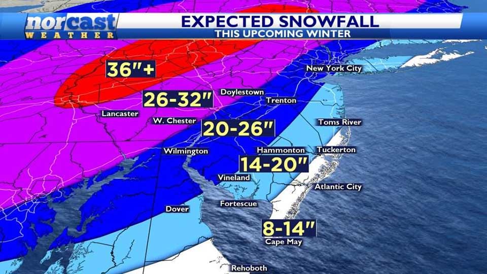
Snowfall Forecast: I’m not promising the world here. I’m staying very close to climatological storms established over the last 50 years. Because of mixing, I am keeping shoreline down to either side of a foot with 14-20 inches possible from eastern Monmouth County down into Ocean, SE Burlington, Atlantic and eastern Cumberland counties.
As you get farther west into Salem, Camden, Gloucester, NW Burlington and the Philly Metro area, 20-26 inches seems reasonable. 676, 55, 95, 295 the Turnpike etc. As we get out of our viewing area and head toward western Pennsylvania and the Poconos, upwards of three feet.
Will it happen? Who knows! The ingredients are there. Can it happen? Absolutely! All of this can change with just one storm. It’s a conservative, middle-of-the-road call. I’m not onboard with Snowmageddon, but I hope I eat those words, in all honesty. We are due for a good winter.
What Can Go Wrong? The southeast ridge. That’s always the wildcard. High pressure sets up off-shore and pumps the jet stream into Canada. This overwhelms the east coast with mild air and pushes the storm track well to our west. When that happens we end up with rain and no snow. Will it make an appearance this year? At some points, I think so. But for how long? That will be determined.
In summary, I think it will be a “decent” winter with a bit of everything for everyone. Not hard to say “more snow than last year,” since we had little to no snow. We will evaluate the forecast in March and not a moment sooner. Get ready for ups and downs, wins and losses. Happens every year.
Follow along @NorEasterNick on all social media channels.