
 The biggest meteorological holiday of the year arrived last Friday, and the famous resident of Punxsutawney, Pennsylvania emerged from his burrow to make his annual Groundhog Day forecast.
Punxsutawney Phil did not see his shadow, thus declaring that spring will arrive early this year.
Phil saw his shadow for the past three years and called for a prolonged winter. This followed 2019 and 2020 when Phil called for spring to arrive early, the first time that the groundhog predicted an early spring in back-to-back years.
The annual Groundhog Day tradition dates back to the 1800s, and massive crowds gather in Punxsutawney every year as people await Phil’s meteorological prognostication.
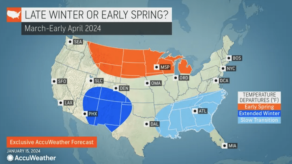
Does Phil’s forecast match AccuWeather’s spring outlook? AccuWeather long-range meteorologists released their annual United States spring forecast just ahead of Groundhog Day, and some parts of the country will indeed see an early arrival of springlike weather, while Old Man Winter will maintain his grip on other regions of the country.
Meteorological spring officially begins on Friday, March 1 while astronomical spring begins on the equinox, which takes place at 11:06 p.m. EDT on March 19.
AccuWeather’s team of long-range forecasters also had the scoop on Punxsutawney Phil, who, on February 2, did not see his shadow and predicted an early spring. Springlike weather could be late to arrive in more than a dozen states across the southern United States, while an early end to winter is possible in regions of the Northern tier.
When can folks safely stow away their snow shovels for the season? Will severe weather be hyperactive in Tornado Alley? Read on to find out the answers to these questions and more with AccuWeather’s 2024 spring forecast:
Spring snow to precede surging warmth: The snow drought finally came to an end in major cities along the Interstate 95 corridor following more than 700 consecutive days without an inch of snow accumulating—and there will be more chances for snow as spring gets underway.
 The window of opportunity for snowstorms in the East will remain open through the first half of March, bringing the chance of plowable snow and providing a nice boost to ski resorts across the region. Afterwards, the weather pattern will flip and the risk of significant snowfall will diminish for most of the East Coast.
“We may actually see a warmup in the second half of March across the eastern U.S.,” AccuWeather’s Paul Pastelok said. He added that there could be some additional chances for snow across the interior Northeast into April, but the odds for meaningful snow accumulation in places like New York City, Philadelphia and Washington, DC will be low after mid-March.
The stormy pattern will not let up despite the surge in temperatures, and the abundance of rainfall in April could bog down parts of the eastern U.S., especially across the Southeast.
Drought conditions have been improving across the region throughout the winter months, and systems swinging through the Southeast will continue to erase the rainfall deficits in the coming months. However, the rain could end up being too much of a good thing.
Springtime rainstorms will have the potential to trigger flooding from the Gulf Coast through the mid-Atlantic.
The prospects of frequent rainfall in the Southeast could also limit temperatures, resulting in a slower transition from winter to spring conditions.
As the calendar flips to May, residents across the Southeast should also start to prepare for the impending Atlantic hurricane season, as 2024 could feature a tropical system before the season officially gets underway on June 1.
“It may not take much to get a tropical storm in May to form, especially around the Florida Peninsula and maybe southeast Texas where water [in the Gulf of Mexico] is warmer,” Pastelok explained. However, any system that tries to develop would have to battle disruptive winds expected over the Gulf of Mexico throughout most of May, which could work to limit the system’s strength.
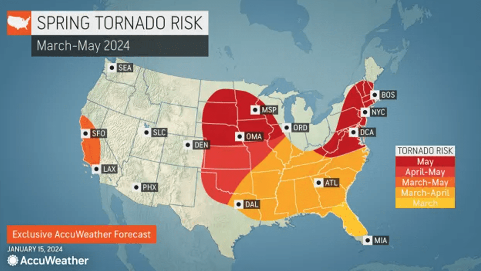
Tornado Alley to reignite in April, May: The arrival of spring signals the start of severe weather season across the nation’s heartland, and AccuWeather meteorologists say the worst of the thunderstorms and tornadoes could focus on a different area than recent years when severe weather blitzed the Tennessee Valley and Mississippi Valley.
Severe weather may fire up early across the Gulf Coast states in March and will shift and expand across the Plains through April and into May, encompassing the traditional Tornado Alley. Damaging winds and hail will be most prevalent while the number of tornadoes throughout the season could finish slightly lower than the historical average, especially in March and April.
“May is when the tornadoes start to really come about,” Pastelok said.
Parts of the mid-Atlantic and New England can also expect an uptick in severe weather in May as well.